


Gifting Made Simple
Give the Gift of ChoiceClick below to purchase a Prairie Mall eGift Card that can be used at participating retailers at Prairie Mall.Buy Gift CardHome
Sarnia Windsor Lake Huron Coast Street Atlas
Coles
Loading Inventory...
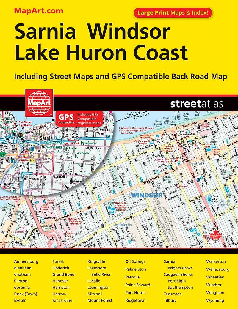
Sarnia Windsor Lake Huron Coast Street Atlas in Grande Prairie, AB
Current price: $12.95
Coles
Sarnia Windsor Lake Huron Coast Street Atlas in Grande Prairie, AB
Current price: $12.95
Loading Inventory...
Size: Paperback
*Product information and pricing may vary - to confirm current pricing, availability, shipping, and return information please contact Coles. In the event of a pricing discrepancy, the retailer's price will apply.
It’s the definitive auto companion for travel in this area, whether you are a resident or short-term visitor. It’s got all the features to make even the unfamiliar areas easy to navigate.
Inside this 112 page atlas you will find city maps (1:21,000), regional maps (1:250,000), locator maps, feature listings (points of interest, hospitals,golf), street index, regional map community and road indexes.
City mapping includes Amherstburg, Blenheim, Chatham, Clinton, Corunna, Essex (Town), Exeter, Forest, Goderich, Grand Bend, Hanover, Harriston, Harrow, Kincardine, Kingsville, Lakeshore (Belle River), LaSalle, Leamington, Mitchell, Mount Forest, Oil Springs, Palmerston, Petrolia, Point Edward, Port Huron, Ridgetown, Sarnia (Brights Grove), Saugeen Shores (Port Elgin, Southampton), Tecumseh, Tilbury, Walkerton, Wallaceburg, Wheatley, Windsor, Wingham and Wyoming.
The detailed city maps features include divided highways, major roads, secondary roads, main thoroughfares, minor streets, lanes / private streets, interchange numbers, one way streets, street address numbers, railways, VIA Rail stations, Detroit People Mover, bus stations, ferries, carpool parking, border crossings, international boundaries, municipal boundaries, recreation trails, parks / conservation areas, golf courses, commercial areas, cemeteries, institutional areas, industrial areas, special attraction areas, hospitals, tourist information centres, police stations, fire halls, libraries, points of interest, beer stores, liquor stores, wineries, casinos, national parks / historic sites, arenas, community / recreation centres, pools, baseball, soccer, tennis, campgrounds, public and catholic schools.
The back road maps features include expressways to seasonal roads, airports, train stations, ferries, locks, lock numbers, OPP, hospitals, customs, tourist information centres, rapids, waterfalls, beaches, peaks, mines, rest areas, skiing, golf, wharfs, boat launches, marinas, landmarks, campgrounds, UNESCO World Heritage sites, National Historic sites, bird watching, viewpoints/looksouts, lighthouses, National and Provincial parks, greenbelts, conservation areas, bird sanctuaries, populations and more.
Saddlestitched bound
Dimensions: 21 x 28 cm (8.375 x 10.875 inches)
Proudly made in Canada!
Provinces/Territories: Ontario
It’s the definitive auto companion for travel in this area, whether you are a resident or short-term visitor. It’s got all the features to make even the unfamiliar areas easy to navigate.
Inside this 112 page atlas you will find city maps (1:21,000), regional maps (1:250,000), locator maps, feature listings (points of interest, hospitals,golf), street index, regional map community and road indexes.
City mapping includes Amherstburg, Blenheim, Chatham, Clinton, Corunna, Essex (Town), Exeter, Forest, Goderich, Grand Bend, Hanover, Harriston, Harrow, Kincardine, Kingsville, Lakeshore (Belle River), LaSalle, Leamington, Mitchell, Mount Forest, Oil Springs, Palmerston, Petrolia, Point Edward, Port Huron, Ridgetown, Sarnia (Brights Grove), Saugeen Shores (Port Elgin, Southampton), Tecumseh, Tilbury, Walkerton, Wallaceburg, Wheatley, Windsor, Wingham and Wyoming.
The detailed city maps features include divided highways, major roads, secondary roads, main thoroughfares, minor streets, lanes / private streets, interchange numbers, one way streets, street address numbers, railways, VIA Rail stations, Detroit People Mover, bus stations, ferries, carpool parking, border crossings, international boundaries, municipal boundaries, recreation trails, parks / conservation areas, golf courses, commercial areas, cemeteries, institutional areas, industrial areas, special attraction areas, hospitals, tourist information centres, police stations, fire halls, libraries, points of interest, beer stores, liquor stores, wineries, casinos, national parks / historic sites, arenas, community / recreation centres, pools, baseball, soccer, tennis, campgrounds, public and catholic schools.
The back road maps features include expressways to seasonal roads, airports, train stations, ferries, locks, lock numbers, OPP, hospitals, customs, tourist information centres, rapids, waterfalls, beaches, peaks, mines, rest areas, skiing, golf, wharfs, boat launches, marinas, landmarks, campgrounds, UNESCO World Heritage sites, National Historic sites, bird watching, viewpoints/looksouts, lighthouses, National and Provincial parks, greenbelts, conservation areas, bird sanctuaries, populations and more.
Saddlestitched bound
Dimensions: 21 x 28 cm (8.375 x 10.875 inches)
Proudly made in Canada!
Provinces/Territories: Ontario
You May Also Like














Find at Prairie Mall in Grande Prairie, AB
Visit at Prairie Mall in Grande Prairie, AB